Beauties and beasts, the AW list of 13 challenging routes
Tue, 07 Dec 2010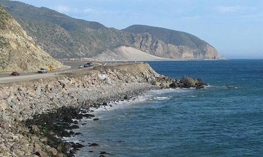
Everyone has an opinion about the worst road in America--usually it's one in their neighborhood. We poked around and compiled our own list of the 13 roads, highways and interchanges that you should pay attention to--for good or bad reason. Good traction and four-wheel drive can't shield you from falling rocks or shoulderless mountain passes. You may simply want to avoid some of the following routes, no matter what you're driving.
1. U.S. 550 between Silverton and Ouray, Colorado
Leave your million-dollar car at home if you're going to brave the “Million Dollar Highway,” a.k.a., U.S. 550. Known for its scenic terrain, lack of guardrails and hairpin turns, truckers have dubbed it the most dangerous highway in America. Steep cliffs and narrow lanes complement huge gorges and mountain passes. The highway becomes a major avalanche zone in the winter. Truckers say migrating wildlife cause roadblocks in the fall.
2. U.S. 101 at I-405 in Los Angeles
This spot was rated the most congested area in the country by the American Highway Users Alliance. There are more than 27,000 hours of delay to motorists every year from traffic at the interchange. If the route was improved from an F to a D rating--where there is basically no stop and go traffic--it would prevent about 9,017 crashes every 20 years, save 36 lives and keep 4,427 people from sustaining injuries.
3. I-15 through Nevada
This is a well-traveled path through the desert to Las Vegas that has few rest stops. Naturally, people speed through it, which accounts for most of the deaths--more than 170 by 2005--along the 124-mile stretch.
4. I-10 through Louisiana
Louisiana consistently has the second-highest fatality rate per 100 million vehicles driven over the past few years, according to the National Highway Traffic Safety Administration. I-10 was obliterated after Hurricane Katrina and has since gone through numerous repairs. Potholes and water damage splatter the route, and the pavement is susceptible to moving along with the flooded soil beneath.
5. I-80 through Wyoming
One AutoWeek staffer warned against the stretch between Cheyenne and Laramie, where I-80 reaches its maximum elevation at 8,640 feet. Farther west, it cuts through the Red Desert and over the Continental Divide.
6. Rabbit Ears Pass, U.S. 40 in Colorado
This one also crosses the Continental Divide, and you might as well turn the car off if it starts snowing. Despite a lower elevation than many of the southern passes, Rabbit Ears gets a ton of snow in the winter at just higher than 9,400 feet in the Rockies. There is a single off-ramp for refuge on the steeply descending western side of the pass--just in case your brakes overheat while descending the incline. There are frequent road closures there.
7. Pacific Coast Highway, Route 1 through California
In the words of one AW staffer: Pick a spot, any spot, along the coast where the beauty is matched only by the sheer size of the drop from the road to the rocks below.
8. I-610 at the I-10 interchange in Houston
First off, the National Motorists Association found that Houston has the highest number of speed traps of any city in America--373 to be exact. Next, this interchange is rated the second worst bottleneck in the country as a major commuter route, with more than 25 million hours of delay annually.
9. I-90/94 at I-290 Circle Interchange in Chicago
This area is a maze of traffic with winding entrance ramps spaced too closely together, narrow lanes and too many signs. Right in the heart of downtown Chicago, it is a mess during rush hour.
10. I-5 in San Diego
This highway is full of high school speeders just ripe for a DUI while crossing the U.S.-Mexico border on the way to or from Tijuana. About 25 people per day are arrested for drinking violations in San Diego County alone.
11. U.S. Route 17 near Beaufort County, South Carolina
This route is so ridiculously hilly that you literally cannot see what's coming, whether it's a deer or a mountain lion in your path, or just another blinding turn. The narrow lanes add to the hazard.
12. I-285 at the I-85 interchange in Atlanta
You'll probably get stuck behind a truck no matter where you are during stop-and-go traffic. The area is a complex mess of circles and overlapping highways with narrow lanes.
13. U.S. 19 in Florida
One five-year study recorded 100 pedestrians killed and 262 deaths total. A “Dateline NBC” study rated it the most dangerous road in the country, specifically the stretch from Pasco to Pinellas County.
Soon you might be able to watch out for these rough spots on your car's navigation system. iRAP--an international roads-assessment program--just completed phase three of testing in the United States. It identifies high-risk roads in America and around the globe and works with local officials to try to correct the problems.
Mappers are currently gathering baseline video for the navigation systems. A star-rating system is in place to rate roads around the nation based on features correlated with crashes. AAA said it hopes to get the program running within the next year so that GPS mapping can detect road hazards.
If you think U.S. roads are bad, check out some international death traps, or the 15 most dangerous places to drive on earth, here: http://cardetailing.org/15-most-dangerous-places-drive-earth
By Michelle Koueiter