Brand:Garmin
Manufacturer Part Number:010-00667-41
GPSMAP 696 Receiver, with XM Capability, Americas, by GarminMeet Garmin's ultimate portable MFD: the GPSMAP 696, an all-in-one navigator designed exclusively for aviation. Featuring a large screen, detailed electronic charts and weather data, the 696 is your own personal avionics system. See the Big PictureThe GPSMAP 696’s bright 7" diagonal high-definition sunlight-readable display makes detailed mapping easy to see day or night — you can even view an entire approach plate on the large-format display. For easy operation, the bezel around the screen includes soft keys and a joystick control. And the internal GPS provides position updates five times per second (5 Hz), allowing the 696 to present flight data smoothly and continuously. No Chart? No Problem.With the addition of IFR map mode, Garmin FliteCharts® and ChartView™, the GPSMAP 696 provides key functions of a Class 1/Class 2 electronic flight bag (EFB), reducing the use of paper charts in the cockpit. When in IFR map mode, the 696 can display victor airways, jet routes, minimum enroute altitudes and leg distance, much like what’s found on traditional enroute charts. With FliteCharts, you can quickly find and view all U.S. AeroNav Services, standard terminal arrival routes (STARs), approach charts and airport diagrams. A geo-referenced version of FliteCharts will be available in late 2010, which will provide you with an on-screen representation of your aircraft’s exact position overlaid directly onto these charts. For pilots who prefer Jeppesen charts and diagrams, Garmin also offers ChartView. The ChartView service utilizes Jeppesen’s extensive library to provide global geo-referenced charting capabilities (Chartview activation instructions).
Add Weather and RadioThe GPSMAP 696 includes a GXM 42 smart antenna, which gives you access to high-resolution weather and audio entertainment right in the cockpit (XM subscription required). XM WX™ Satellite Weather includes next generation radar (NEXRAD), aviation routine weather reports (METARs), terminal aerodrome forecasts (TAFs), temporary flight restrictions (TFRs), lightning, winds aloft and more for the U.S. and Canada. In addition, the 696 can receive PIREPs, turbulence forecast and icing forecast information. The weather data can be laid directly over the unit’s navigation and topographic map databases. With 170+ channels of digital music, news and programming through your aircraft headset or cabin audio system, you’ll stay informed and entertained. Enhance Situational AwarenessThe GPSMAP 696 features a high-resolution terrain page showing hazards relative to your altitude and a vertical profile of terrain along your route of flight. It comes with a built-in Jeppesen database, and an Americas, Atlantic or Pacific terrain database. It also includes an obstacles database for the U.S. or Europe. Using this information, the 696 displays your flight route over contour terrain mapping. With information from the terrain and obstacles databases, the 696 monitors your current position in relation to surrounding terrain to provide alerts. To help keep pilots aware of special airspace activity, over 683 parachute drop zones are detailed in the Americas navigation database. You can even customize your own minimum clearance levels to receive terrain cautions. The 696 also comes with a realistic “view from space” satellite imagery basemap.
Like other portable Garmin devices, the 696 includes the following enhanced aviation databases: - Garmin SafeTaxi®: Provides detailed taxiway diagrams and position information for many U.S. or European airports. Preloaded on the unit, this information helps you navigate unfamiliar airports with confidence and shows your aircraft’s exact position on the field.
- AOPA Airport Directory: Offers detailed information for more than 5,300 U.S. airports, along with the names and phone numbers of thousands of FBOs. Easily look up taxi services, plan an overnight, and choose fuel stops, plus find ground transportation, lodging, restaurants, local attractions and more.
- Private Airports and Heliports: Provides data on private airports and heliports throughout U.S. and Europe, and materially expands your list of navigation and emergency "nearest" options.
Receive Altitude-Sensitive AlertsWhen in the air, Garmin’s new Smart Airspace™ feature makes it easier than ever to identify what airspace lies ahead. Smart Airspace automatically highlights airspace close to your current altitude and de-emphasizes airspace away from the current altitude, which gives you increased situational awareness. Expand Your PortableThe GPSMAP 696 includes an SD™ card slot for extra memory and updates. Keep track of the databases on your GPSMAP 696 through www(dot)fly(dot)garmin(dot)com, the online manager that helps you update, manage and purchase the latest aviation data for your Garmin device, all in one place.
Physical & Performance | | Physical dimensions | 5.7"W x 7.7"H x 2.0"D (14.5 x 19.5 x 5.1 cm) | | Display size, WxH | 3.6"W x 6.0"H (9.1 x 15.2 cm); 7.0" diag (17.78 cm) | | Display resolution, WxH | 480 x 800 pixels | | Display type | bright, color WVGA TFT with adjustable backlighting | | Weight | 35.7 ounces (1012 g) with battery pack; 22.4 ounces (635 g) without battery pack; 12.7 ounces (361 g) RAM mount | | Battery | rechargeable, replaceable Nickel-Metal Hydride | | Battery life | up to 2.5 hours with full backlight and GXM 40 connected (8 hours with 50% backlighting and XM connected) | | Water rating | No | | SBAS/WAAS receiver | high-sensitivity with WAAS position accuracy | | IFR or VFR | VFR |
Maps, Databases & Memory | | Basemap | Yes | | Navigation database (includes Jeppesen® data) | Yes | | Types of Jeppesen data | full and ARTCC, FSS frequencies and final approach waypoints | | Navigation database coverage areas | Americas or Atlantic or Pacific | | Preloaded Terrain database | Yes | | Preloaded Obstacle database | Yes (U.S. and Europe only) | | Preloaded SafeTaxi™ airport diagrams | Yes (U.S. only) | | Preloaded AOPA Airport Directory | Yes (U.S. only) | | Preloaded Garmin FliteCharts® | Yes (U.S. only) | | Preloaded low & high altitude enroute airways | Yes | | Preloaded private airports | Yes (U.S. only) | | Preloaded street maps | No | | Ability to add maps | Yes | | Accepts data cards | yes (SD cards) | | Built-in memory | internal solid state | | Waypoints/favorites/locations | 3,000 | | Routes | 50 |
Features & Benefits | | Moving map | Yes | | Patented panel page | Yes | | HSI (GPS-based) | Yes | | IFR map mode | Yes | | Traffic Information Services (TIS) alerts compatible | Yes | | Audible terrain alerts | Yes | | Terrain resolution | standard | | Smart Airspace Feature (generates and displays altitude-sensitive alerts) | Yes | | Automatic logbook | Yes | | Separate serial and USB interfaces | Yes | | Speaks street names (e.g. "Turn right ON ELM STREET in 500 ft.") | No | | Lane assist (guides to proper lane for navigation) | No | | 3-D map view | No | | Bluetooth® wireless technology | no | | Speed limit indicator (displays speed limit for most major roads in the U.S. and Europe) | No | | Traffic compatible (routes around traffic with a receiver and subscription) | No | | Custom POIs (ability to add additional points of interest) | No | | SiriusXM™ Weather & Radio compatible | Yes | | Additional | Nominal operating velocity: 800 Knots/411.56 (m/s) |
|
GPS for Sale
Tue, 04 Dec 2012
You can tell a lot about a person from the car they drive. It can also be argued that you can tell a lot of about a car from who drives it, especially when that person is a respected designer, in this case the head of Design Bugatti Achim Anscheidt. In one of Drive's latest episodes features Anscheidt and his Porsche ‘Private Project' 911 around the streets of Berlin, discussing his take on minimalism in design and construction and how he feels about personal design projects.
Mon, 20 Apr 2009
By Ben Pulman
First Official Pictures
20 April 2009 10:01
This is the first picture of Jaguar’s new XJ saloon. Revealed to the world’s media at Jaguar’s press conference at the Shanghai motor show today, it gives us a glimpse of the new Jaguar saloon that will be fully revealed on July 9 2009. Jaguar also released a video of the XJ, which can be viewed at the bottom of this page.
Thu, 14 Nov 2013
While American teenagers were cruising around in finned interstate crushers, Europeans of all ages were discovering the wonder of automobile ownership thanks to the tiny, affordable Fiat Nuova 500, introduced to a car-hungry public in 1957. The little two-cylinder city car was a smash hit, with 3,893,294 built before production ended in 1975. Fiat 500 production resumed in 2007, but the new car was vastly different from the original: Its engine gained two cylinders and moved to the front of the car, while its footprint, though diminutive by American standards, positively dwarfs that of its predecessor.
2040Parts.com © 2012-2025. All Rights Reserved.
Designated trademarks and brands are the property of their respective owners.
Use of this Web site constitutes acceptance of the 2040Parts User Agreement and Privacy Policy.
0.072 s, 12152 u
|

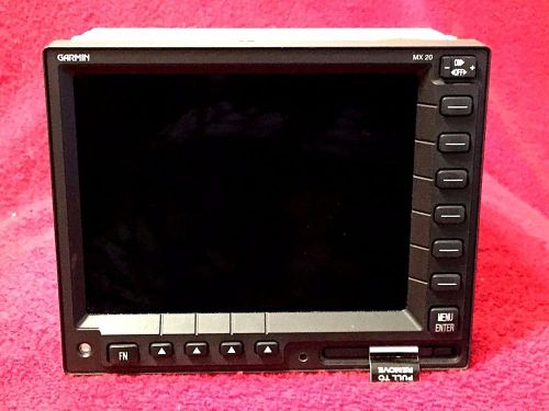 Garmin at apollo mx 20 multi function display p/n 430-0270-701 & tray connector
 Stratus2 ads-b/gps receoiver
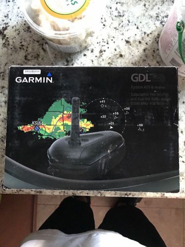 Garmin gdl 39 new
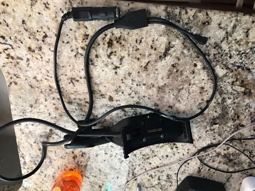 Garmin aera 796/795 mount + ram mount
 King kmd 150 mfd with gps and rack
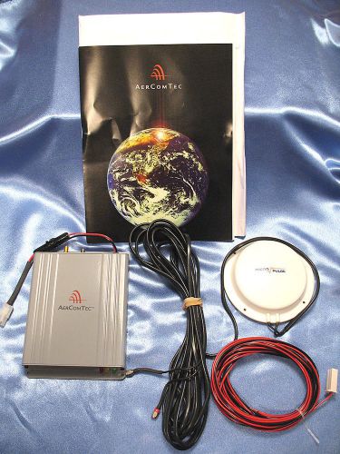 Aercomtec aertrax m-1 micro pulse gps cellular antenna tracking system nib!!
