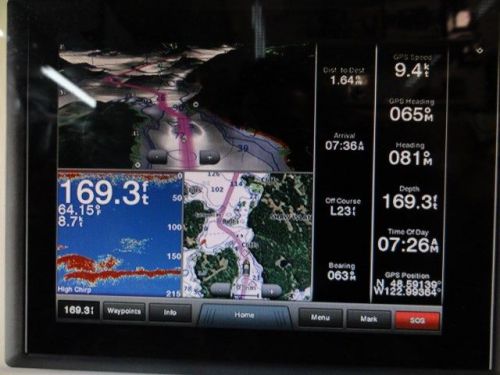
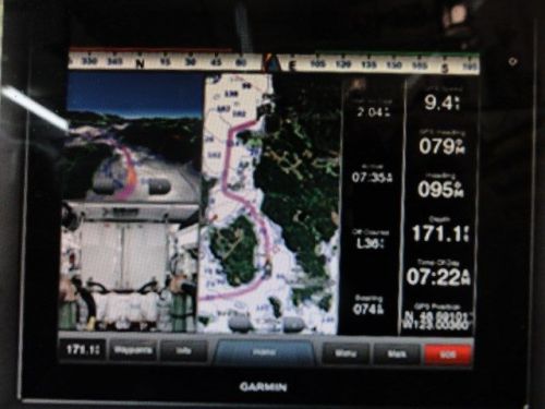
Multi-touch Glass Helm Display
The bright, crisp XGA touchscreen comes standard with preloaded BlueChart® g2 maps of the U.S. coast* and includes pinch-to-zoom and other touch controls for intuitive operation. Anti-glare and LED backlighting makes it easy to view in bright sunlight. And auto-dimming provides outstanding visibility at night.
Full System Integration

GPSMAP 8215 integrates various sonar technologies as well as autopilot, connectivity, apps, engine data and multi-media. User data can be automatically synced for all networked 8000 series chartplotters across multiple helms — everything you need is at your fingertips, all on one screen. A full digital switching system uses CZone technology. You can power up your boat while away from the dock; switch on pumps; and control lights, even underwater lights. Nearly all of your controls are available right at your fingertips either at the helm, or programmed into a remote key fob, or an app on your tablet provided by CZone by Mastervolt.
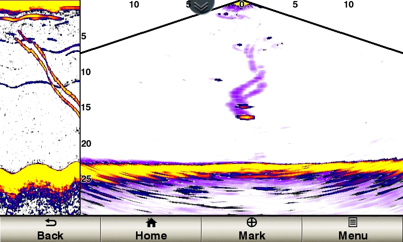
Supports DownVü and SideVü Scanning Sonar
Add a GCV 10 scanning sonar module that provides both DownVü and SideVü scanning sonar with CHIRP technology. It delivers the clearest scanning sonar images on the water. You see ultra-clear images of objects, structure and fish that pass below (DownVü) and to the sides (SideVü) of the boat.
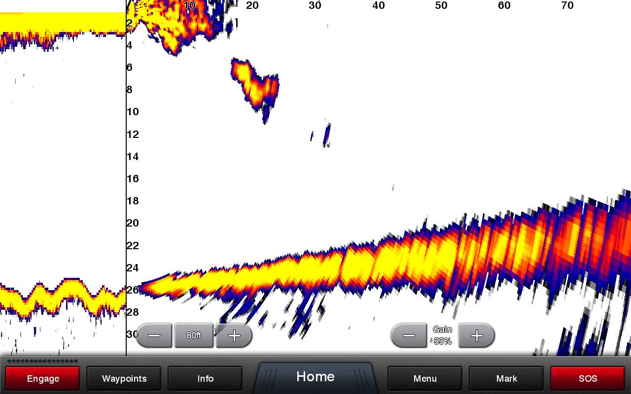
Advantages of CHIRP Technology
When used with the GSD 26 CHIRP professional sonar module (sold separately), GPSMAP 8215 displays crystal-clear sonar images to help find the next hidden fishing spot, ship wreckage or diving location. Garmin CHIRP sonar allows you to see target separation and resolution at extraordinary depths, and dial into specific frequencies to target certain species of sport fish. Bottom contours are more visible, and signal noise can be suppressed at greater depths to provide a more timely interpretation of what’s below for safer navigation and better fishing.
View Multiple Sonar Sources Simultaneously
GSD 26 CHIRP professional sonar, GSD 24 advanced sonar, and GCV 10 DownVü and SideVü scanning sonar can exist on the same system. You can view various sonars together on one monitor or across multiple monitors in multi-display systems.
Customize Layouts with SmartMode
You can quickly change all screens at a helm in sync to a preset mode with the SmartMode. Switch all monitors in sync from one mode to another without manually switching each monitor separately. Fully customizable layouts, data and gauges allow you to place the information you need to see right where you want it. Add Garmin Helm™, a free app, that allows you to view and control your compatible Garmin chartplotter from an iPhone® or iPad®. Use SmartMode to easily switch between multiple chartplotters with screen thumbnails by station (requires Garmin Marine Wi-Fi Adapter, sold separately).
High Performance System
External GPS19x smart antenna with 10 Hz GPS/GLONASS receiver updates position and heading 10 times per second to display a more fluid vessel movement and dramatically improves your ability to accurately mark and navigate to 5,000 waypoints.
Includes BlueChart g2
BlueChart g2 marine maps feature crisp labeling and an overall smooth presentation on your chartplotter display. In addition to the basic charts, tidal stations, currents, depth contours, IALA symbols and included fishing charts, BlueChart g2 offers smooth transitions between zoom levels and seamless continuity across chart boundaries. Covered by our exclusive New Chart Guarantee.
Special Features for Sailing
Supported sailing features include laylines, enhanced wind rose, heading and course-over-ground lines, true wind data fields and tide/current/time slider. Gauge displays are designed to provide important need-to-know information at a glance, including true and apparent wind angle, set and drift, true or apparent wind speed, horizontal or vertical graphs, and a data bar with customizable data fields.
GND™ 10 Black Box Interface
The GND 10 black box interface seamlessly integrates Nexus instruments and sensors with the Garmin family. It converts data between the Nexus network and NMEA 2000® to provide trouble-free compatibility between Nexus and Garmin products, including gWind™ and gWind Race wind transducers.
Compatible with gWind Transducers
Garmin gWind, gWind Wireless and gWind Race transducers feature twin-fin technology with 3-bladed propeller. Connect to the NMEA 2000 and compatible Garmin chartplotters via the GND 10 black box bridge.
FLIR Camera Compatible
Control fix-mounted FLIR M-Series and MD-Series thermal night vision systems from your Glass Helm.
GRID™ (Garmin Remote Input Device)
GRID is a remote device that provides full control of all GPSMAP 8000 Glass Helm series devices. Rotary knob and joystick controls provide navigation through menus and screens and allows you to seamlessly navigate between monitors at a station. Control single or multiple monitors with one device. Supports multiple devices per station. GRID can rotate to allow vertical or horizontal installation. Small footprint can be integrated into a captain’s chair (sold separately).
FUSION-Link Entertainment System
Enjoy the ability to control all compatible FUSION-Link-enabled audio systems directly from your compatible chartplotter display.
SiriusXM Support
Enjoy full control of your SiriusXM music and entertainment on the chartplotter screen.
Free Garmin Helm App
Garmin Helm allows you to view and control your compatible Garmin chartplotter from an iPhone or iPad, or phone or tablet using Android™ — while providing enhanced situational awareness for the mariner. Easily switch between portrait and landscape mode to accommodate mounting preferences. Using your Apple digital mobile device, you can even record a movie of your chartplotter screen to share with friends and family. Download from the App Store™ or Google Play™ today (requires Garmin Marine Wi-Fi Adapter Kit sold separately).
Flexible Mounting Options
The 8215 MFD is compatible with our low-profile flush mount. For the ultimate in custom appearance, check out our exclusive flat-mount glass helm option.
Enhanced Auto Guidance
Just enter the location where you want to go and patented Garmin Auto Guidance technology instantly searches through relevant charts to create a safe virtual pathway on the display that helps you avoid low bridges, shallow water and other charted obstructions en route.
Better still, with enhanced Version 2.0, you now have access to even more features and capabilities. You’re able to adjust the calculated Auto Guidance pathway by inserting “via” points at interim stops or landmarks along your desired route. You can easily review hazard points along your calculated path. And you can even engage your compatible Garmin autopilot to follow the Auto Guidance route, automatically. Other 2.0 enhancements give you the ability to calculate arrival times at any point on your route (great for timing arrivals to correspond with bridge openings and other time-critical events). Better still, you can now save your plotted Auto Guidance paths for future navigation by backing them up on an SD™ card with your BlueChart® g2 Vision® or Lake Vü™ HD Ultra cartography¹.
Simplified SOS Calling
This exclusive SOS safety assist feature makes it easier for anyone – even those not familiar with marine electronics or radio protocols – to quickly call for Coast Guard help in an emergency. By simply tapping the SOS button on the chartplotter’s touchscreen display, your networked Garmin VHF radio will automatically tune to the Channel 16 emergency frequency and a list of possible situations (Ffire, man overboard, etc.) will be displayed. Once the applicable choice has been selected, the screen will provide a Coast Guard approved VHF radio distress call script, along with the ship’s current lat/long GPS coordinates, that can be read off to responders – thus saving time, averting panic, and providing the essential information needed by rescuers to assure the best possible outcome.
GPX Waypoints Transfer
If you have waypoints, tracks or frequently used routes stored on another manufacturer’s GPS product – or on a Garmin handheld device – now it’s easier than ever to transfer those items to your new Garmin chartplotter, via industry-standard GPX software formatting. GPX is an open standard format for GPS data exchange across platforms and applications. With this easy-to-use interface technology, Garmin has taken “no waypoint left behind” to a whole new level of trade-up convenience.
Special Sailing Features
To help you gain a wind-maximizing competitive edge, your chartplotter features a pre-race guidance page that shows your virtual starting line, along with data fields showing laylines, time to burn before the start and a race timer that can be synchronized across all your networked Garmin GPS products. In addition, other supported sailing features include an enhanced wind rose, heading and course-over-ground lines, set and drift, true and apparent wind data and more. You can also use available built-in wireless connectivity to access and control a variety of marine-specific apps via compatible smartphones or tablets.
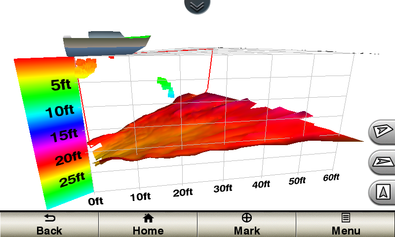
Panoptix™ Down Transducer
With 1 Panoptix Down transducer, you get 3 remarkable views, allowing you to actually see fish and bait swimming around under your boat – in real time. You can even see fish in the water column in 3-D, from the bottom to the surface. You can be stationary yet still see things in 3-D below your boat.
LIVEVÜ DOWN
Shows real-time moving sonar images below the boat. This screen shows bait drop echo trail movement in purple with sonar history data at left.
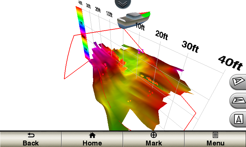
REALVÜ 3-D DOWN
Scans the area below the boat from front to back and side to side. This screen shows a school of fish sitting against the back side of vertical face, on Pport side of boat 35 feet deep.
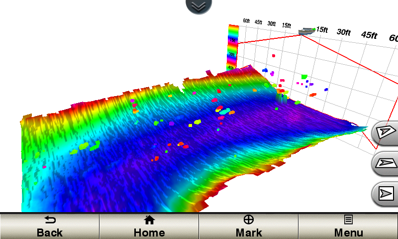
REALVÜ 3-D HISTORICAL
Scrolls through the data as the boat moves to show the history of entire water columns – from the bottom to the surface and all of the fish in between. This screen shows the boat passing over a stream channel with a school of fish between 30 to 40 feet.
Panoptix Forward Transducer
One Panoptix Forward transducer provides 2 impressive views, even while your boat is stationary. It shows the bottom plus fish and bait swimming in the water column in front of your boat – in real time. You can even see your lure as you reel it in. You can also get 3-D views of fish and structure in front of your boat.
LIVEVÜ FORWARD
Updates are provided with a single ping, providing real-time moving images of what’s in the water. This screen shows a large target (a diver) approaching the boat.
REALVÜ 3-D FORWARD
Digitally scans the area in front of the boat, creating a forward-looking 3-D view of the bottom, structure and fish. This screen shows fish targets at 10 feet and drawing bottom depth of 20 feet.


 New garmin gpsmap 8212 mfd
 Carlingswitch 50 amp dc circuit breakers 2 each
 Golight stryker 3049r remote control spotlight
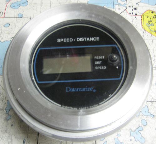 Datamarine s100kl speed/distance gauge
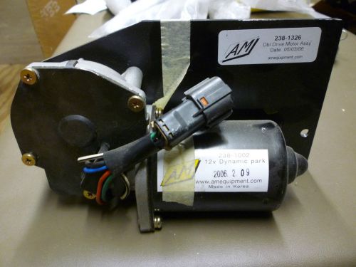 Am 12v dynamic park wiper motor w/ double drive motor assembly
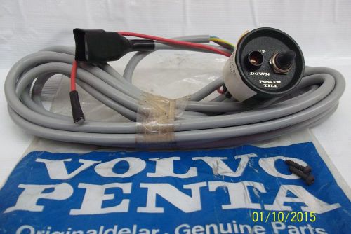 Volvo penta - 850375 - 12v instrument panel