Garmin 7610xsv on 2040-parts.com
Baltimore, Maryland, United States
|
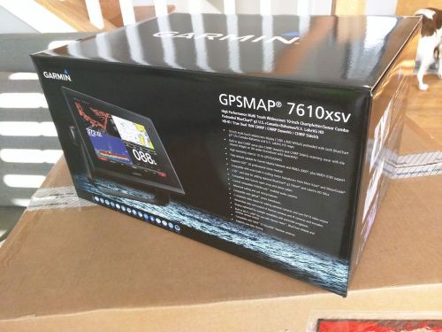
This unit is brand new, never installed. Message if you have any questions. No international shipping. Standard ground shipping included to continental US. Here is the description from Garmin's website: 10-inch Multi-touch Widescreen Chartplotter/Sonar Combo
Designed for sportfishermen, cruisers, sailors and sailing racers who demand high performance, ease of operation and feature integration in a chartplotter/sonar combo. The 10-inch multi-touch widescreen GPSMAP 7610xsv combo includes built-in dual CHIRP sonar plus CHIRP DownVü and CHIRP SideVü scanning sonar with the clearest images on the water. Its internal 10 Hz GPS updates your position and heading 10 times per second. GPSMAP 7610xsv is fully network capable, including Garmin Network and NMEA 2000, and offers the conveniences of built-in Wi-Fi® connectivity. Built-in Advanced Sonar CapabilitiesThe built-in sonar capabilities of the GPSMAP 7610xsv include 1 kW dual CHIRP sonar, the most sophisticated sonar technology available for the fishing and boating public. Dual CHIRP sonar provides amazingly clear target separation and definition because it puts even more energy onto the target than CHIRP. It gives you the ability to show low/high, med/high or low/med on the screen at the same time, enhancing your ability to distinguish between game fish and balls of bait fish. It also includes both CHIRP DownVü and CHIRP SideVü scanning sonar that provide nearly photographic sonar images of fish and structure that passes below and to the sides of your boat. DownVü and SideVü provide the clearest scanning sonar images on the water. Also supported are 50 kHz/200 kHz, 77 kHz/200 kHz and Minn Kota® and MotorGuide® trolling motor transducers (sold separately). GPSMAP also includes sonar-recording capability that coordinates the timing of the sonar return with your boat's position and saves digital information for playback on a computer using HomePort™ planning software. Preloaded BlueChart g2 mapsIn addition to basic charts, tidal stations, currents, depth contours, IALA symbols and included fishing charts, BlueChart g2 offers smooth transitioning between zoom levels and more seamless continuity across chart boundaries. You can customize your screens with Safety Shading that allows you to shade all depth contours shallower than your boat’s safe depth. Fishing charts emphasize bathymetric contours with less visual clutter on the display. And there’s also a choice of standard 2-D direct overhead or 3-D “over-the-bow” map views for easier chart reading and orientation. Preloaded LakeVü HD mapsThese highly detailed freshwater maps include 17,000+ U.S. lakes, rivers and reservoirs. Included in those are more than 6,700 HD lakes with 1-foot contours shoreline to shoreline; excellent detail of underwater features plus Safety Shading that allows you to designate a minimum depth; interstates, highways, general roads and bridges; designated fishing areas; and points of interest, such as docks, boat ramps, marinas and campgrounds. Garmin Marine Network and NMEA 2000 SupportFull-network compatibility allows you to add more capabilities to your boat. GPSMAP 7610xsv supports radar, autopilot, instruments, multiple screens, FUSION-Link, sensors, remote sonar modules, digital switching, thermal cameras, GRID rotary knob, joystick and keypad control, GXM™ 52 marine weather receiver and more. Add Array or Dome RadarYou can add your choice of Garmin marine radar, including our powerful xHD2 open array radars or xHD dome radars that pairs ease of use with advanced open array features. Network SharingGPSMAP 7610xsv allows you to share features with other compatible GPSMAP units, such as radar, GSD 24, GSD 25 and GSD 26 sonar modules, supplemental maps, and user data, including waypoints, routes and tracks. User data entered into 1 chartplotter can be automatically synced with other chartplotters in a network. Heading and Position Refreshed 10 Times Per SecondFast, responsive 10 Hz GPS/GLONASS refreshes your position and heading 10 times each second to make your movement on the screen more fluid. It makes dropping up to 5,000 accurate waypoints — and finding your way back to them — quick and easy. Upgrade with the Best Maps on the WaterTwo SD™ card slots provide expandable memory for accessory map purchases, such as LakeVü HD Ultra with Max Def Lakes or BlueChart g2 Vision that add Garmin patented Auto Guidance and other great features. FUSION-Link Entertainment SystemEnjoy the ability to control all compatible FUSION-Link-enabled audio systems directly from your compatible chartplotter display. Built-in Wi-Fi/ANT+™Built-in Wi-Fi/ANT for use with Garmin Helm™ and BlueChart Mobile. Compatible with gWind™ TransducersGarmin gWind, gWind Wireless and gWind Race transducers feature twin-fin technology with 3-bladed propeller. Connect to the NMEA 2000 and compatible Garmin chartplotters via the GND™ 10 black box bridge. Black Box InterfaceThe GND 10 black box interface seamlessly integrates Nexus instruments and sensors with the Garmin family. It converts data between the Nexus network and NMEA 2000 to provide trouble-free compatibility between Nexus and Garmin products. View and Control Your Device from a Smartphone or TabletGarmin Helm allows you to view and control your compatible Garmin chartplotter from a compatible smartphone or tablet while providing enhanced situational awareness for the mariner. Easily switch between portrait and landscape mode to accommodate mounting preferences. When using an iPhone® or iPad®, you can even record a movie of your chartplotter screen to share with friends and family. Download from The App Store™ or Google Play™. Get Your Apple® Device Onboard with BlueChart MobileWith BlueChart Mobile, a free app downloaded from the App Store, you can plan marine routes on your iPad or iPhone then wirelessly transfer them to your boat’s compatible networked Garmin chartplotter. Even if you don’t have a Garmin chartplotter, you can still take advantage of the tremendous features of BlueChart on your Apple device. Enhanced Auto GuidanceJust enter the location where you want to go and patented Garmin Auto Guidance technology instantly searches through relevant charts to create a safe virtual pathway on the display that helps you avoid low bridges, shallow water and other charted obstructions en route. Better still, with enhanced Version 2.0, you now have access to even more features and capabilities. You’re able to adjust the calculated Auto Guidance pathway by inserting “via” points at interim stops or landmarks along your desired route. You can easily review hazard points along your calculated path. And you can even engage your compatible Garmin autopilot to follow the Auto Guidance route, automatically. Other 2.0 enhancements give you the ability to calculate arrival times at any point on your route (great for timing arrivals to correspond with bridge openings and other time-critical events). Better still, you can now save your plotted Auto Guidance paths for future navigation by backing them up on an SD™ card with your BlueChart® g2 Vision® or Garmin LakeVü™ HD Ultra cartography¹. Simplified SOS CallingThis exclusive SOS safety assist feature makes it easier for anyone – even those not familiar with marine electronics or radio protocols – to quickly call for Coast Guard help in an emergency. By simply tapping the SOS button on the chartplotter’s touchscreen display, your networked Garmin VHF radio will automatically tune to the Channel 16 emergency frequency and a list of possible situations (fire, man overboard, etc.) will be displayed. Once the applicable choice has been selected, the screen will provide a Coast Guard approved VHF radio distress call script, along with the ship’s current lat/long GPS coordinates, that can be read off to responders – thus saving time, averting panic, and providing the essential information needed by rescuers to assure the best possible outcome. GPX Waypoints TransferIf you have waypoints, tracks or frequently used routes stored on another manufacturer’s GPS product – or on a Garmin handheld device – now it’s easier than ever to transfer those items to your new Garmin chartplotter, via industry-standard GPX software formatting. GPX is an open standard format for GPS data exchange across platforms and applications. With this easy-to-use interface technology, Garmin has taken “no waypoint left behind” to a whole new level of trade-up convenience. Special Sailing FeaturesTo help you gain a wind-maximizing competitive edge, your chartplotter features a pre-race guidance page that shows your virtual starting line, along with data fields showing laylines, time to burn before the start and a race timer that can be synchronized across all your networked Garmin GPS products. In addition, other supported sailing features include an enhanced wind rose, heading and course-over-ground lines, set and drift, true and apparent wind data and more. You can also use available built-in wireless connectivity to access and control a variety of marine-specific apps via compatible smartphones or tablets. Panoptix™ Down TransducerWith 1 Panoptix Down transducer, you get 3 remarkable views, allowing you to actually see fish and bait swimming around under your boat – in real time. You can even see fish in the water column in 3-D, from the bottom to the surface. You can be stationary yet still see things in 3-D below your boat. Panoptix Forward TransducerOne Panoptix Forward transducer provides 2 impressive views, even while your boat is stationary. It shows the bottom plus fish and bait swimming in the water column in front of your boat – in real time. You can even see your lure as you reel it in. You can also get 3-D views of fish and structure in front of your boat. Create your own HD mapsQuickdraw Contours is a free, easy-to-use software feature already installed on your compatible Garmin combo. It instantly creates your own personalized HD fishing maps with 1-foot contours. Tailor them to fit your needs. They are your maps — you own them. Keep the data to yourself, or share it with the Quickdraw Community on Garmin Connect™. There’s no special surveying expertise required. You just fish while it creates maps. You don’t have to wait around or send your files away like other mapping software requires — your results appear instantly. Use with any of the following sonar transducers: Garmin Panoptix™, HD-ID™ traditional, CHIRP-enabled, Garmin DownVü™ or NMEA 2000®-compatible depth. Have more than 1 sonar device installed onboard? Quickdraw Contours automatically selects the most capable sonar device to provide the very best results for you! Multiple Depth Range ShadingDesignate up to 10 different depth ranges each with its own color. Makes it easier to view target depths at a glance. Commission Autopilot from ChartplotterTo make commissioning easier and more convenient, you can handle the entire autopilot commissioning process from your chartplotter screen. Axis Camera SupportGarmin offers support for select Axis cameras, which can be used for surveillance and situational awareness on vessels of any size. Our integration allows you to view video on every screen on your boat and, if you wish, view multiple streams on the same screen. You can control your camera's pinch-to-zoom and pan/tilt settings with gestures directly on the plotter screen. Use an Axis encoder to convert analog camera, such as Garmin GC 10, to video over IP. Catch All the Action On the WaterThis chartplotter supports wireless connections to Garmin VIRB® X and XE action cameras so you can catch all the action during your time on the water. More importantly, with a simple software update, you can control recordings, take still pictures, and stream video from a VIRB X/XE action camera to your GPSMAP® 7400/7600 series chartplotter or 8000/8400/8600 series Glass Helm chartplotter. In fact, you can stream video from up to 4 VIRB X/XE action cameras and view the video on a compatible marine chartplotter. You can even view previously captured images and videos on the chartplotter and display thumbnail previews for easy selection. Control play, pause, seek and replay from your chartplotter. There’s even an automatic slide show mode and the ability to delete unwanted VIRB images or videos. Each VIRB can be named for easy identification. You can also control your VIRB cameras to change VIRB video settings, including aspect ratio, video resolution, frames per second, photo size, field of view and more — directly from the marine chartplotter. Send NMEA 2000 boat information from the chartplotter to VIRB X/XE to be overlaid as G-Metrix™ data on the video using VIRB Edit or the VIRB mobile app. Some data requires optional accessories. |
GPS & Chartplotters for Sale
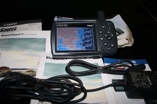 Garmin 276c marine gps(US $399.00)
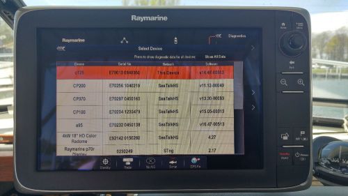 Raymarine c125 wide screen multifunction display unit(US $1,755.00)
 Furuno navnet vx2/rdp-149(US $1,450.00)
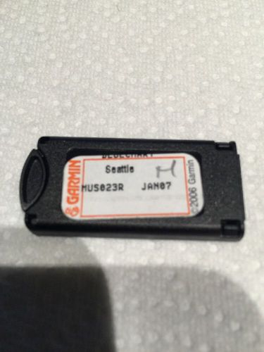 Garmin bluechart us023r seattle data card(US $95.60)
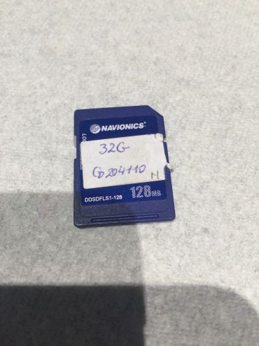 Navionics sd gold 32g australia(US $199.80)
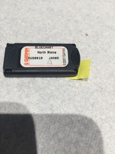 Garmin bluechart north maine us001r 2005(US $92.00)
Shelby raffles off last 50th-anniversary Cobra
Thu, 19 Jan 2012Shelby is celebrating its 50th anniversary in style, first at the Detroit auto show with a few black-and-gold Shelby Mustangs, and now at the Barrett-Jackson auction in Arizona with the last example of the 50th-anniversary Shelby Cobra. The car won't be sold to the highest bidder though; it will be raffled. Tickets cost $25 apiece or five for $100.
2013 Aston Martin Vanquish: New photos and new video
Sat, 08 Sep 2012The new Aston Martin Vanquish is heading for Paris 2012 and Aston Martin has released new photos and video of their range-topper. The 2013 Vanquish gets extra power – it now delivers 565bhp and 456lb/ft of torque – which propels it to 62mph in 4.1 seconds and on to 183mph, sharper new looks with hints of the One-77 and lots of carbon fibre, and a new list price that is still the right side of £200k – £189,995. And perhaps delivering new photos and video of the 2013 Vanquish is Aston Martin’s way of making sure the Vanquish has its moment in the sun ahead of the reveal of the new DB9.
Car choices: Men are from Italy, women are from Sweden
Wed, 25 Apr 2012In a study result that surprises no one, it turns out that women prefer small cars and crossovers while men like Ferraris. At least according to TrueCar's annual report on the subject, that is. Mini, Nissan, Kia and Honda models are purchased by women about 45 percent of the time.