Garmin Gpsmap7612xsv 12" Multi-touch Widescreen Chartplotter/sonar Combo on 2040-parts.com
Denver, Colorado, United States
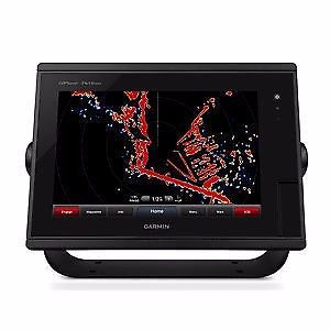
12-inch Multi-touch Widescreen Chartplotter/Sonar Combo
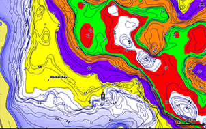
Designed for sportfishermen, cruisers, sailors and sailing racers who demand high performance, ease of operation and feature integration in a chartplotter/sonar combo. The 12-inch multi-touch widescreen GPSMAP 7612xsv combo includes built-in dual CHIRP sonar plus CHIRP DownVü and CHIRP SideVü scanning sonar with the clearest images on the water. Its internal 10 Hz GPS updates your position and heading 10 times per second. GPSMAP 7612xsv is fully network capable, including Garmin Network and NMEA 2000, and offers the conveniences of built-in Wi-Fi® connectivity. Built-in Advanced Sonar CapabilitiesThe built-in sonar capabilities of the GPSMAP 7612xsv include 1 kW dual CHIRP sonar, the most sophisticated sonar technology available for the fishing and boating public. Dual CHIRP sonar provides amazingly clear target separation and definition because it puts even more energy onto the target than CHIRP. It gives you the ability to show low/high, med/high or low/med on the screen at the same time, enhancing your ability to distinguish between game fish and balls of bait fish. It also includes both CHIRP DownVü and CHIRP SideVüscanning sonar that provide nearly photographic sonar images of fish and structure that passes below and to the sides of your boat. Garmin DownVü and SideVü provide the clearest scanning sonar images on the water. Also supported are 50 kHz/200 kHz, 77 kHz/200 kHz and Minn Kota® and MotorGuide® trolling motor transducers (sold separately). GPSMAP also includes sonar-recording capability that coordinates the timing of the sonar return with your boat's position and saves digital information for playback on a computer using HomePort™ planning software. Preloaded BlueChart g2 mapsIn addition to basic charts, tidal stations, currents, depth contours, IALA symbols and included fishing charts, BlueChart g2 offers smooth transitioning between zoom levels and more seamless continuity across chart boundaries. You can customize your screens with Safety Shading that allows you to shade all depth contours shallower than your boat’s safe depth. Fishing charts emphasize bathymetric contours with less visual clutter on the display. And there’s also a choice of standard 2-D direct overhead or 3-D “over-the-bow” map views for easier chart reading and orientation. Preloaded LakeVü HD MapsThese highly detailed freshwater maps include 17,000+ U.S. lakes, rivers and reservoirs. Included in those are more than 13,000 HD lakes with 1-foot contours shoreline to shoreline; excellent detail of underwater features plus Shallow Water Shading that allows you to designate a minimum depth; interstates, highways, general roads and bridges; designated fishing areas; and points of interest, such as docks, boat ramps, marinas and campgrounds. Garmin Marine Network and NMEA 2000 SupportFull-network compatibility allows you to add more capabilities to your boat. GPSMAP 7612xsv supports radar, autopilot, instruments, multiple screens, FUSION-Link, sensors, remote sonar modules, digital switching, thermal cameras, GRID rotary knob, joystick and keypad control, GXM™ 52 marine weather receiver and more. Add Array or Dome RadarYou can add your choice of Garmin marine radar, including our powerful xHD2 open array radars or xHD dome radars that pairs ease of use with advanced open array features. Network SharingGPSMAP 7612xsv allows you to share features with other compatible GPSMAP units, such as radar, GSD 24,GSD 25 and GSD 26 sonar modules, supplemental maps, and user data, including waypoints, routes and tracks. User data entered into 1 chartplotter can be automatically synced with other chartplotters in a network. Heading and Position Refreshed 10 Times Per SecondFast, responsive 10 Hz GPS/GLONASS refreshes your position and heading 10 times each second to make your movement on the screen more fluid. It makes dropping up to 5,000 accurate waypoints — and finding your way back to them — quick and easy. Upgrade with the Best Maps on the WaterTwo SD™ card slots provide expandable memory for accessory map purchases, such as LakeVü HD Ultrawith Max Def Lakes or BlueChart g2 Vision that add Garmin patented Auto Guidance and other great features. FUSION-Link Entertainment SystemEnjoy the ability to control all compatible FUSION-Link-enabled audio systems directly from your compatible chartplotter display. Built-in Wi-Fi/ANT+™Built-in Wi-Fi/ANT for use with Garmin Helm™ and BlueChart Mobile. Compatible with gWind™ TransducersGarmin gWind, gWind Wireless and gWind Race transducers feature twin-fin technology with 3-bladed propeller. Connect to the NMEA 2000 and compatible Garmin chartplotters via the GND™ 10 black box bridge. Black Box InterfaceThe GND 10 black box interface seamlessly integrates Nexus instruments and sensors with the Garmin family. It converts data between the Nexus network and NMEA 2000 to provide trouble-free compatibility between Nexus and Garmin products. View and Control Your Device from a Smartphone or TabletGarmin Helm allows you to view and control your compatible Garmin chartplotter from a compatible smartphone or tablet while providing enhanced situational awareness for the mariner. Easily switch between portrait and landscape mode to accommodate mounting preferences. When using an iPhone® or iPad®, you can even record a movie of your chartplotter screen to share with friends and family. Download from The App Store™ or Google Play™. Get Your Apple® Device Onboard with BlueChart MobileWith BlueChart Mobile, a free app downloaded from the App Store, you can plan marine routes on your iPad or iPhone then wirelessly transfer them to your boat’s compatible networked Garmin chartplotter. Even if you don’t have a Garmin chartplotter, you can still take advantage of the tremendous features of BlueChart on your Apple device. Enhanced Auto GuidanceJust enter the location where you want to go and patented Garmin Auto Guidance technology instantly searches through relevant charts to create a safe virtual pathway on the display that helps you avoid low bridges, shallow water and other charted obstructions en route. Better still, with enhanced Version 2.0, you now have access to even more features and capabilities. You’re able to adjust the calculated Auto Guidance pathway by inserting “via” points at interim stops or landmarks along your desired route. You can easily review hazard points along your calculated path. And you can even engage your compatible Garmin autopilot to follow the Auto Guidance route, automatically. Other 2.0 enhancements give you the ability to calculate arrival times at any point on your route (great for timing arrivals to correspond with bridge openings and other time-critical events). Better still, you can now save your plotted Auto Guidance paths for future navigation by backing them up on an SD™ card with your BlueChart® g2 Vision® or Lake Vü™ HD Ultra cartography¹. Simplified SOS CallingThis exclusive SOS safety assist feature makes it easier for anyone – even those not familiar with marine electronics or radio protocols – to quickly call for Coast Guard help in an emergency. By simply tapping the SOS button on the chartplotter’s touchscreen display, your networked Garmin VHF radio will automatically tune to the Channel 16 emergency frequency and a list of possible situations (fire, man overboard, etc.) will be displayed. Once the applicable choice has been selected, the screen will provide a Coast Guard approved VHF radio distress call script, along with the ship’s current lat/long GPS coordinates, that can be read off to responders – thus saving time, averting panic, and providing the essential information needed by rescuers to assure the best possible outcome. GPX Waypoints TransferIf you have waypoints, tracks or frequently used routes stored on another manufacturer’s GPS product – or on a Garmin handheld device – now it’s easier than ever to transfer those items to your new Garmin chartplotter, via industry-standard GPX software formatting. GPX is an open standard format for GPS data exchange across platforms and applications. With this easy-to-use interface technology, Garmin has taken “no waypoint left behind” to a whole new level of trade-up convenience. Special Sailing FeaturesTo help you gain a wind-maximizing competitive edge, your chartplotter features a pre-race guidance page that shows your virtual starting line, along with data fields showing laylines, time to burn before the start and a race timer that can be synchronized across all your networked Garmin GPS products. In addition, other supported sailing features include an enhanced wind rose, heading and course-over-ground lines, set and drift, true and apparent wind data and more. You can also use available built-in wireless connectivity to access and control a variety of marine-specific apps via compatible smartphones or tablets. Panoptix™ Down TransducerWith 1 Panoptix Down transducer, you get 3 remarkable views, allowing you to actually see fish and bait swimming around under your boat – in real time. You can even see fish in the water column in 3-D, from the bottom to the surface. You can be stationary yet still see things in 3-D below your boat. 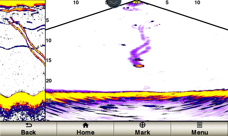 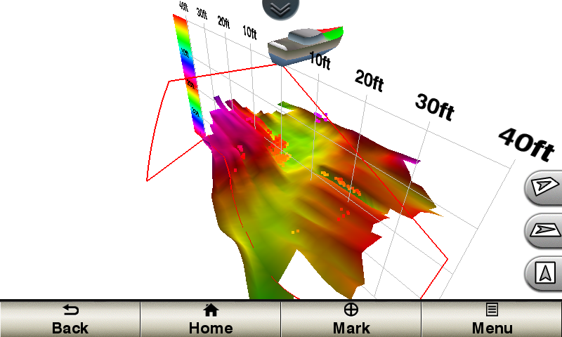 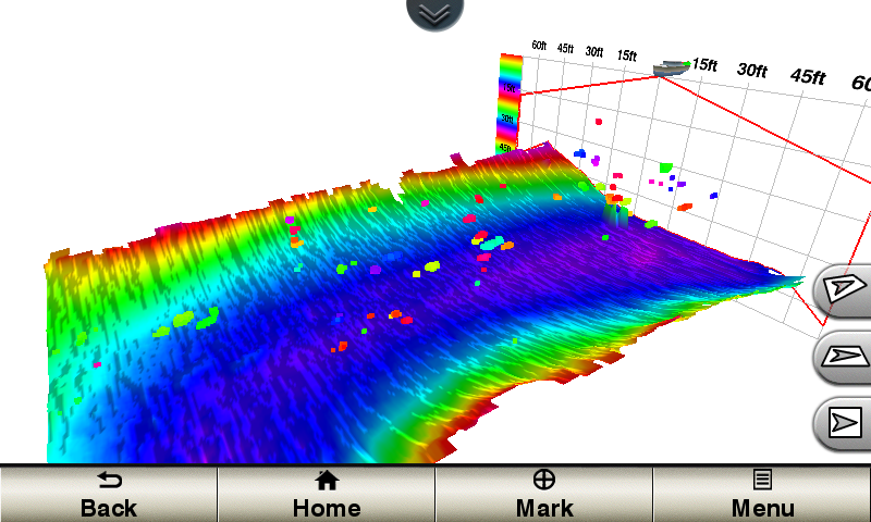 LIVEVÜ DOWNShows real-time moving sonar images below the boat. This screen shows bait drop echo trail movement in purple with sonar history data at left. REALVÜ 3-D DOWNScans the area below the boat from front to back and side to side. This screen shows a school of fish sitting against the back side of vertical face, on Pport side of boat 35 feet deep. REALVÜ 3-D HISTORICALScrolls through the data as the boat moves to show the history of entire water columns – from the bottom to the surface and all of the fish in between. This screen shows the boat passing over a stream channel with a school of fish between 30 to 40 feet. Panoptix Forward TransducerOne Panoptix Forward transducer provides 2 impressive views, even while your boat is stationary. It shows the bottom plus fish and bait swimming in the water column in front of your boat – in real time. You can even see your lure as you reel it in. You can also get 3-D views of fish and structure in front of your boat. 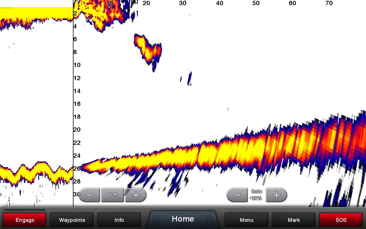 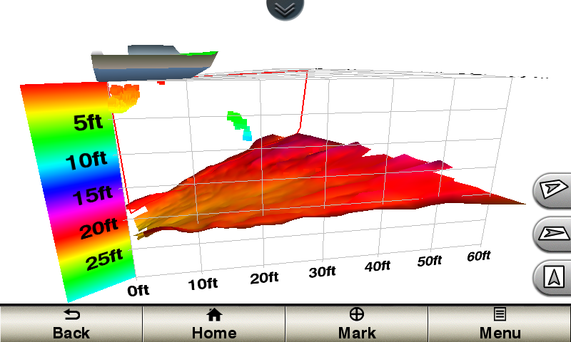 LIVEVÜ FORWARDUpdates are provided with a single ping, providing real-time moving images of what’s in the water. This screen shows a large target (a diver) approaching the boat. REALVÜ 3-D FORWARDDigitally scans the area in front of the boat, creating a forward-looking 3-D view of the bottom, structure and fish. This screen shows fish targets at 10 feet and drawing bottom depth of 20 feet. Create your own HD mapsQuickdraw Contours is a free, easy-to-use software feature that is already installed on your compatible Garmin device. It instantly creates your very own personalized HD fishing maps with 1-foot contours. Tailor them to fit your needs. They are your maps. You own them. Keep the data to yourself or share it with Garmin or your friends. There’s no special surveying expertise required. You just fish while it creates maps. You don’t have to wait around or send your files away like other mapping software requires — your results appear instantly. Use with any Garmin Panoptix™, any HD-ID™, any CHIRP-enabled, Garmin DownVü™ transducer or NMEA 2000®-compatible depth transducer. Have more than 1 sonar device installed onboard? Quickdraw Contours automatically selects the most capable sonar device to provide the very best results for you! Multiple Depth Range ShadingDesignate up to 10 different depth ranges each with its own color. Makes it easier to view target depths at a glance.
Commission Autopilot from ChartplotterTo make commissioning easier and more convenient, you can handle the entire autopilot commissioning process from your chartplotter screen. |
Fish Finders & Depth Finders for Sale
 Lowrance hook-4x fishfinder w/83/200 transom mount transducer(US $184.70)
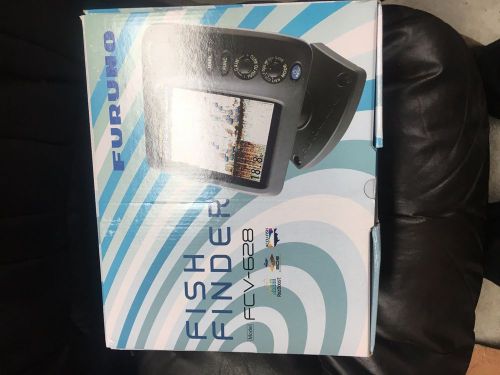 Furuno fcv-628 fish finder(US $575.00)
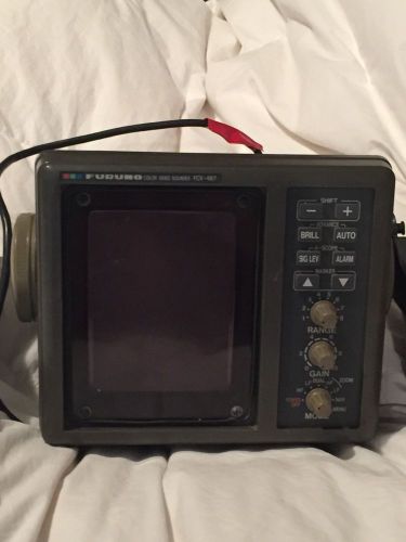 Furuno fcv 667 color depth finder fish finder speed gps(US $400.00)
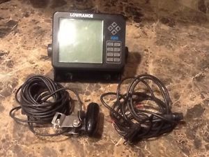 Lowrance x85 fish finder sonar, inc. transducer, cables, head and base, complete(US $150.00)
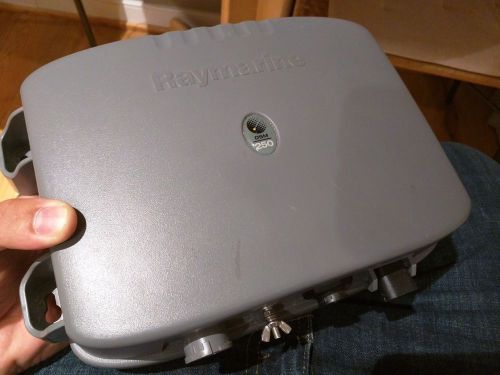 Raymarine dsm250 - e62007(US $150.00)
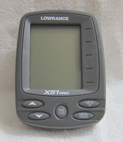 Lowrance fishfinder x51pro control head only with owner's manual(US $40.00)
Pagani Zonda F Cinque – er, no it’s not!
Fri, 06 Mar 2009The mysterious 'Zonda F Cinque' - which is actually a Regular Zonda Cinque But we are still to see the Zonda Cinque (which is essentially a tamed-down Zonda R for the road) in the wild, and probably because of that the car sites around the world were full of a mysterious ‘Zonda F Cinque’ that was going to turn up at the Geneva Motor Show. But we had our doubts. We have pretty good contacts at Pagani, and although we knew that the Pagani coming to Geneva was in fact the Cinque (as well as the Zonda R) we wanted to work out where the rumour came from.
MINI Rocketman could be heading for production – if BMW can find a chassis
Fri, 29 Nov 2013The ‘Mini’ MINI Rocketman (pictured) could go in to production The MINI Rocketman Concept was revealed at the Geneva Motor Show in 2011 as a smaller MINI than the one BMW were selling at the time, and it looked like BMW were considering going the smaller route to make the MINI more fun. But with the 2014 MINI now revealed, BMW has gone the opposite route by underpinning the new MINI with the UKL platform that will also underpin the next BMW 1 Series, and made the latest MINI even bigger than the last one. But it seems BMW still see mileage in a ‘Mini MINI’ and appear keen to find a way to make the Rocketman a production reality.
Help MSN Cars and Driver Power to find Britain's best - and worst - new cars
Tue, 25 Feb 2014Getty We're on a quest to find Britain's best new cars to buy and own - and we need your help. MSN Cars has teamed up with the Driver Power survey, Britain's biggest report of its type. It speaks to real motorists to find out what they think of their cars.